


The EC’s Joint Research Centre has developed software to identify the position of ships in real time, to aid in countering piracy.
The software, the Piracy, Maritime Awareness and Risks (PMAR) system, is the result of a two year study carried out by JRC and the prototype will be tested in Kenya, hosted by the Kenyan Maritime Authority.
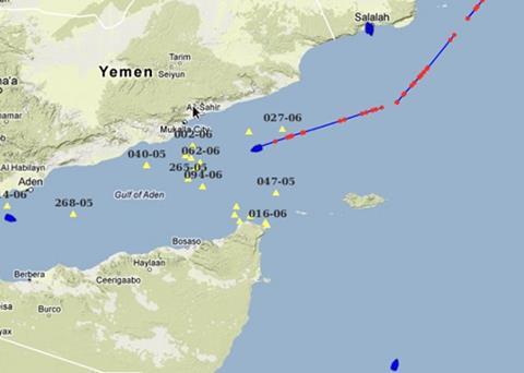
The project that led to its development studied technologies intended to build up maritime awareness and was tailored for use by authorities in regions affected by piracy. This software integrates data from vessel reporting and earth observation systems into one single maritime picture, taking into account a wide array of available data sources. The maritime picture indicates the estimated current ship positions in real-time, with an update every 15 minutes. Historic piracy risk occurrence and ship traffic density maps are also produced.
PMAR has a regional approach in providing a wide (Western Indian Ocean) maritime situational picture. JRC says that this is one of the necessary building blocks in fighting piracy as it complements the coastal picture that can be observed by individual countries. It can also be used for other purposes like combating illegal fisheries or illegal immigration.