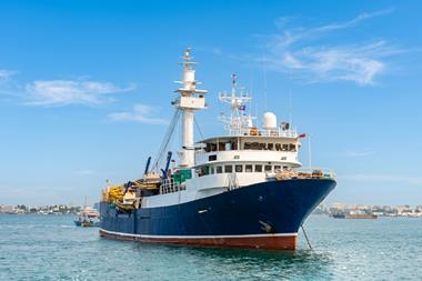


Vessel Monitoring Systems or VMS is not a new concept for the fishing industry. The system by which fishing vessels are detected and identified is one of the key practices used by many fishing regulating bodies to manage fish stocks, as well as monitor operators in the industry. But as fishing regulations evolve, tracking requirements are progressively being extended to cover smaller vessels.
In addition, the urgent need to rehabilitate and protect fishing stocks is also demanding VMS deploys more technologically advanced terminals and software that can support more sophisticated functions beyond monitoring current vessel location.
In Europe however, the social and political climate around issues such as, sustainability of marine resources, and food security, have resulted in a drive towards providing definitive fisheries management policies and systems through the use of technology. The result has been evident with the creation of various EU legislations that require all member state vessels over 12 metres to have VMS by 2012.
While fishing VMS provide many benefits including protection of fishing stocks as well as protection of the economic livelihood of the fishing community, implementation and acceptance can be slow.
Challenges often include the numerous types of satellite communication equipment and services that can be used for monitoring, financial and administrative costs of implementation for the fishermen and the regulatory authorities, changes and advances in technology as well as general acceptance from the fishing community.
The Irish Sea-Fisheries Protection Authority (SFPA) is one organisation that experienced some of these challenges when they implemented their first VMS system in 2000. According to Patrick Allen, secure VMS project manager from SFPA, up to seven different models of satellite communication equipment were type approved for their first VMS system.
This led to a greater management effort to approve and integrate the information from the various models into the central database. It was also very difficult to ensure the integrity of the data supplied to the VMS information management system.
Finally, there were numerous incidents of vessels leaving port without their VMS tracking units switched on or of position data being interfered with.
In 2007, following a number of visits from the European Commission, the SFPA and their control partners the Irish Naval Service, carried out a review of the Irish VMS solution. It was felt that there were a number of weaknesses in the system and the partners decided to examine alternative solutions.
The following year, the SFPA issued a request for tender for their Secure VMS Terminals Project that would see the replacement of approximately 230 VMS terminals on Irish fishing vessels exceeding 15 metres in overall length.
“Prior to going to the market the SFPA knew that the new terminals would need to meet the basic reporting requirements of sending the vessels identity and position every two hours. The vessels geographical position required an accuracy of less than 500 metres and the two hourly report would have to include the date and time of position fixing, as well as the course and speed of the fishing vessel,” said Allen.
“However, we were also aware of the advancements in satellite communication technology and the possibility of getting added value with the new terminals.”
The contract to implement the Secure VMS Terminals project was awarded to Satlink SL from Spain. With previous experience in implementing VMS systems for Spain, Ecuador, Panama and other countries in South America, the Secure VMS project challenged the engineering organisation to develop its VMS system to a whole new level as well as improve on the deficiencies from the previous system.
“The agility and configurability required by the Irish VMS system coupled with the cost constraints meant we needed to implement a revolutionary solution,” said Jens Heinsdorf, CTO at Satlink.
The tracking device selected to meet the needs of the project was a DMR-800L satellite communication terminal from SkyWave Mobile Communications. The terminal, which uses the Inmarsat IsatM2M satellite data communication service, was primarily selected for its costs and advanced in-terminal programming capability that would support the new requirements set forth by the SFPA.
“The fact that the terminal did not have an on/off button and consequently did not require intervention from the fishermen was also a reason for selecting the DMR-800L terminal,” said Allen.
The system
Due to cost and the advanced monitoring requirements of the system, the DMR-800L was the only communication terminal that was type approved for the Irish Secure VMS Terminals project.
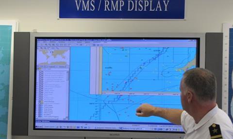
It was configured by Satlink engineers with the assistance from SkyWave’s field application engineering team with a Satlink VMS user programme (script) that sends messages to the Satlink’s Bluebox interface server. This server operates within the Irish Fisheries Monitoring Centre (FMC) which is located in the Irish Naval Service’s Base overlooking the town of Cobh in Cork harbour.
The terminal securely sends VMS information through the Inmarsat satellite network using the IsatM2M protocol to the FMC, where the data is fed into the Fishery Information Systems (FIS) and Fishery Geographic System (FGS), thereby enabling the SFPA and Irish Naval Service to track, monitor and direct all fishing vessels operating within Irish waters.
The FIS, developed by the Naval Service, contains a vast library of fisheries data going back more than 20 years which includes VMS positional data as well as sightings by patrol vessels and aircrafts. It also contains records of all inspections as well as data on vessel owners and skippers, warnings detentions etc.
For security reasons, no authorities besides the Irish Naval Service and the SFPA have access to vessel location information. Fishermen have full access to the whereabouts of their own vessels by using a password-protected web -based application developed by Satlink.
“Fishermen accept that information on their whereabouts is necessary to help combat illegal fishing practices, but are less keen when the information they transmit also reveals the location of their fishing grounds. This is why we treat VMS location data as personal information," said lieutenant commander James Deacon from the Irish Naval Service.
The secure nature of the DMR-800L satellite terminal and IsatM2M system also meant that satellite transmissions could not be intercepted and GPS data could not be tampered.
In the zones
While the Satlink Bluebox user interface and the DMR-800L terminal comply with the security and reporting requirements for the project, the revolutionary nature of the Irish Secure VMS system is its ability to pre-define dynamic and complex fishing zones and automatically generate alerts when vessels enter or leave these areas.
Each fishing zone is capable of having its own rules for reporting frequency as well as information sent.
According to Heinsdorf, each DMR-800L communication terminal used in the Secure VMS project has programmed within its memory four different types of zones. The zones define areas within Irish fishing waters that are reserved for fishing, conservation or vessel management.
They are also used to define areas where the Irish fishing authorities require a change in reporting period from the EU-specified two hours. For example, Norwegian waters usually require position information to be transmitted every hour while vessels in European Community waters must transmit their position information typically every two hours.
‘Effort Zones’ are geographical areas where the fishing activity of EU community fishing vessels are managed on the basis of time spent in the area and the vessels power.
The Satlink VMS script within the DMR-800L terminal automatically detects the vessel’s position as it moves between effort zones and transmits this information back to the FMC. This in turn starts/stops the “effort clock” for that particular vessel in that particular effort zone(s). This information is then used firstly to calculate individual vessel effort and then effort usage for different segments of the fleet.
“The Fishing Effort regime is an integral part of the European Common Fisheries Policy (CFP) and our VMS system is used to provide an accurate measure of this effort,” said Allen.
‘Special Areas of Conservation’ (SACs) are defined as areas that are strictly protected. Designed to protect habitats and species of plants and animals, no fishing activity is allowed in these zones.
The Satlink VMS system flags when a fishing vessel enters a SAC zone and automatically switches the reporting interval from once every two hours to once every 15 minutes. This allows the authorities to carefully monitor the activities of the vessel if it enters such an area.
‘Approach Zones’ refer to areas surrounding selected ports. When fishing vessels enter an Approach Zone, the Satlink VMS Script again configures the DMR-800L terminal to transmit the vessel’s GPS position every 15 minutes.
The ability to detect entry into an Approach Zone is an important tool for SFPA inspectors as it pre-warns of approaching vessels, and allows them to prepare for inspection and pinpoints the exact docking time and location - all without the FMC having to manually poll the location of the vessel.
‘Virtual Home Zones’ are defined as areas within the harbour. Since vessels are not required to maintain the two-hour position reporting once they are within the harbour, Virtual Home Zones allow fishermen to avoid unnecessary message transmissions and costs when they are docked.
Since the system automatically detects when the vessel is in a Virtual Home Zone, no manual intervention is required by the fishermen when they enter or exit these zones.
The terminal goes “asleep” when it enters port and only transmits its position to the FMC every 24 hours. However, it will “wake up” at regular intervals to check its position, and if it finds it has moved it will revert to the normal reporting mode.
Over-the-air programming
While current zone information is typically programmed into the device prior to installation, they can be updated and maintained in accordance with latest regulations. Using satellite over-the-air campaigns (OTA), zone changes can be transmitted anytime and as often as required to individual terminals until the complete fleet is updated with the change – all without physically “touching” the terminals.
A recent change to the reporting interval required in the NEAFC area was done using OTA capabilities.
The DMR-800L terminal also has the capability to store position historical information in its memory. Concurrent to the specified VMS reporting frequency, Satlink’s VMS script in the terminal is designed such that the position of the vessel is stored in the non-volatile memory every 15 minutes.
This historic data is particularly important if a vessel is under investigation and the FMC needs to retrieve where the vessel has been. Up to 17,000 GPS positions can be stored and data can be retrieved via satellite even before the vessel docks.
Resounding success
While Allen and Deacon are both extremely pleased with the overall system, one of the greatest advantages of the system is the ease of use and acceptance by the fishermen.
According to Allen, with the Satlink VMS system, the fishermen no longer have to think about turning on and off the terminals – it is automatically done for them.
“But the real bonus for the fisherman is that the ongoing airtime costs are half that of the previous VMS system,” he said.