


Orbimage''s SeaStar Fisheries Information Service, a global supplier of commercial fishing information, will soon launch new products and services for 2002. At the heart of the service is OrbMap, an easy-to-use oceanographic display software for PCs.
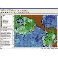
New OrbMap features will include sub-surface temperature, sea surface height alimetry, support for five new languages including French, Spanish, Korean, Japanese and Chinese, an interface to the ship's GPS and new Fish Finding wizards.
Since the early introduction of the SeaStar Service, ORBIMAGE continues to introduce new leading edge information products in response to customer requirements. "ORBIMAGE has always pushed to be the best provider of oceanographic information by listening to the needs of fisherman," states Greg Hammann, Director of Product Development. "OrbMap v5.0 continues this commitment by offering more information and value to the fishermen. Our customers would not continue to subscribe to our service if they were not saving fuel and increasing their catch" says Hammann.
The SeaStar Service has been providing fishing captains daily deliveries of oceanographic information since 1997, along with the powerful tools in OrbMap that assist the captain in making his search decisions. Although some companies had used sea surface temperature (SST) data from weather satellites previously, the SeaStar Service provides important information on plankton concentrations---plankton is the base of the food chain and either directly or indirectly provides the food fish eat. It did not take long for SeaStar Service customers to realise that multiple sources of oceanographic and weather information along with OrbMap is necessary for captains to make better fishing decisions.
How does ORBIMAGE make plankton data available? The SeaWiFS sensor aboard the OrbView-2 satellite was constructed for the purpose of monitoring the world's oceans under a NASA (National Aeronautical and Space Administration) program. ORBIMAGE has exclusive rights to create products from SeaWiFS data for commercial markets, including the fishing industry. For over 300 scientists in the international research community, OrbView-2 SeaWiFS data is viewed as the 'gold-standard' for monitoring ocean color.
ORBIMAGE has created a series of steps to help the captain systematically check each of the data sources that are delivered to their vessel by e-mail. The OrbMap software allows captains to combine and overlay plankton and other relevant information on a single map at the same scale. This makes it easier for fishermen to track ocean changes and focus on conditions that make it more likely to find fish and eliminate unproductive areas.
www.orbimage.com