


Jeppesen''s new C-MAP MAX-N Wide cartography, designed for popular navigation systems from global marine electronics company Navico, is now available to boaters worldwide.
MAX-N Wide is compatible with Lowrance Elite 7 and HDS Gen1, Gen2 and Gen2Touch, Simrad NSS, NSE and NSO, and B&G Zeus Touch Multifunction Navigators.
These advanced navigation systems have earned a loyal worldwide following across a broad spectrum of boaters, including fishermen.
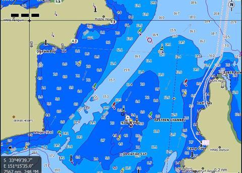
MAX-N Wide electronic charts provide navigators with accurate detail and expansive coverage areas. Now C-MAP MAX-N Wide gives Navico customers access to Jeppesen’s rich chart detail from official and up-to-date sources, including Depth Areas and Contours, Spot Soundings, NavAids, Light Sectors, Wrecks/Obstructions, Anchorage Areas, Small Craft Facilities and more. MAX-N Wide also provides clearly marked boundaries for Restricted, Caution, Fishing and Prohibited Areas - including California’s expanding network of Marine Protected Areas (MPAs).
“MAX-N Wide is an evolutionary product that will continue to grow and offer boaters even more,” said Francesco Altamura, Jeppesen senior manager of Light Marine Global Sales & Portfolio Management. “Jeppesen and Navico are continually working together to bring additional innovative features and important data to boaters. This makes an investment in MAX-N Wide cartography today the first step in an exciting future journey.”
MAX-N Wide will also offer Navico customers easy access to upcoming professional-grade navigation features, such as:
- Auto/Easy Routing
- Route Checking and Guardian (anti-grounding) Technology for safer navigation
- Exclusive Jeppesen High-Resolution Bathymetry for unparalleled presentation of bottom contour
- Dynamic Tides & Current Projections for enhanced fishing and safe, efficient navigation
- High Resolution Aerial Photos of inlets, harbour entrances and land features for improved situational awareness
- Marina Facility Info