
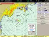
This solution provides extremely cost-effective performance ensuring safer navigation and also reduces radar system installation and maintenance costs on small vessels.
NaviScan can display on a single screen:
• Official ENC charts (S57/S63), and also C-MAP NT Max, C-MAP CM93 ed3
• Radar imaging (with or without Overlay)
• Tracks of other shipping output by ARPA and/or AIS for collision avoidance
• 3D and 4D views (with sedimentology databases (nature of the seabed)).
The high-resolution PC display gives the user a display quality equivalent to that of much more expensive radars.
Data acquisition is via the NetRadar acquisition unit, which can distribute the radar image to one or more PCs over a standard Ethernet network and control it in real time.
NaviScan contains a master interface on the radar for monitoring the radar aerial. This facilitates management and maintenance. It also allows the radar to be easily remote-controlled from the PC.
NaviScan also checks the GPS position. The system indicates differences between the position of a target given by GPS and its position marked on the navigation charts. This provides the navigator with a second source of information to confirm the position of the vessel.